Customer: Kazzinc LLP
Project Goal: Provision of information on the occupied and free contract areas in online mode, simplification of application and increasing the investment attractiveness of the geological industry in the Republic of Kazakhstan.
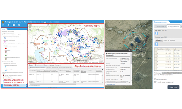
Brief Description: The geographical information system of contract areas "Interactive Map" is developed for the Committee of Geology and Subsoil Use at the RoK Ministry of Industry and Subsoil Use. This system is organized as a web-application on the platform Portal for ArcGIS. In the process of this project implementation, a structure of a single geodatabase was developed for the existing contract areas of solid minerals. All contract areas are displayed in the single coordinate system, attribute information is entered for each allotment that enables one to fast find necessary data. To simplify submission of application by a subsoil user for vacant area, an "Electronic Application" widget was developed that enables one to draw a polygon (site) or enter coordinates manually, fill the attributive information and save the table with coordinates in CSV format.
Results: The unified geodatabase with the existing contract areas and contracts which are at the execution stage has been created. This geodatabase is continually updated which enables one to obtain up-to-date information on land allotments. The application displays the issued allotments (exploration / production) for solid minerals. There are data for each site which include a contract number, type of activity, type of mineral, data on subsoil user and reference details. Data can be searched and grouped by a certain type (mineral, area, subsoil user, etc.), and an electronic application can be filled as well. As a base layer, geological maps, maps of minerals and magnetic anomalies (1:200 000 scale) were added virtually to the entire territory of the country.